fbpx UK Hosts 1st Event at New WAARP Flight Facility | University of Kentucky College of Engineering
×

Error message

  • Deprecated function: Creation of dynamic property MemCacheDrupal::$bin is deprecated in MemCacheDrupal->__construct() (line 30 of /mnt/www/html/ukyengineeringbzaacnspwk/docroot/sites/all/modules/memcache/memcache.inc).
  • Deprecated function: Creation of dynamic property MemCacheDrupal::$wildcard_flushes is deprecated in MemCacheDrupal->reloadVariables() (line 637 of /mnt/www/html/ukyengineeringbzaacnspwk/docroot/sites/all/modules/memcache/memcache.inc).
  • Deprecated function: Creation of dynamic property MemCacheDrupal::$invalidate is deprecated in MemCacheDrupal->reloadVariables() (line 638 of /mnt/www/html/ukyengineeringbzaacnspwk/docroot/sites/all/modules/memcache/memcache.inc).
  • Deprecated function: Creation of dynamic property MemCacheDrupal::$cache_lifetime is deprecated in MemCacheDrupal->reloadVariables() (line 639 of /mnt/www/html/ukyengineeringbzaacnspwk/docroot/sites/all/modules/memcache/memcache.inc).
  • Deprecated function: Creation of dynamic property MemCacheDrupal::$cache_flush is deprecated in MemCacheDrupal->reloadVariables() (line 640 of /mnt/www/html/ukyengineeringbzaacnspwk/docroot/sites/all/modules/memcache/memcache.inc).
  • Deprecated function: Creation of dynamic property MemCacheDrupal::$cache_content_flush is deprecated in MemCacheDrupal->reloadVariables() (line 641 of /mnt/www/html/ukyengineeringbzaacnspwk/docroot/sites/all/modules/memcache/memcache.inc).
  • Deprecated function: Creation of dynamic property MemCacheDrupal::$cache_temporary_flush is deprecated in MemCacheDrupal->reloadVariables() (line 642 of /mnt/www/html/ukyengineeringbzaacnspwk/docroot/sites/all/modules/memcache/memcache.inc).
  • Deprecated function: Creation of dynamic property MemCacheDrupal::$flushed is deprecated in MemCacheDrupal->reloadVariables() (line 643 of /mnt/www/html/ukyengineeringbzaacnspwk/docroot/sites/all/modules/memcache/memcache.inc).

UK Hosts 1st Event at New WAARP Flight Facility

August 11, 2021

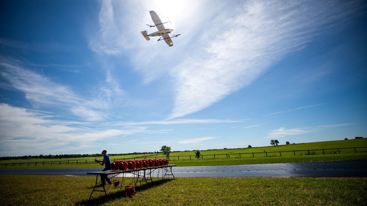
Researchers from the University of Kentucky Department of Mechanical Engineering hosted collaborators from Virginia Tech and Oklahoma State University for a series of unmanned aircraft systems (UAS) flight experiments June 21-24 at the new Wildcat Agricultural and Atmospheric Research Pavilion (WAARP) flight facility. WAARP is located at North Farm off Ironworks Pike, a 971-hectare agricultural research facility operated by the University of Kentucky.

This flight experiment campaign is part of the NASA-sponsored Weather Intelligent Navigation Data and Models for Aviation Planning (WINDMAP) multi-university research collaboration to improve weather awareness for future advanced aerial mobility systems such as drones, air taxis and urban flight management. These future aircraft systems will operate closer to the surface where wind gusts, turbulence, visibility and more are influenced by terrain, tree/crop texture and building geometries among other characteristics. 

Rather than traveling to Colorado for similar facility capabilities, Virginia Tech researchers were able to accomplish their goals at UK’s WAARP. Along with campaign participants, visitors to the event included representatives of the UK EduceLab heritage science team, Proposal Development Office and Office of Technology Commercialization, among others.   

The WAARP flight facility was designed by Michael Sama in the Department of Biosystems and Agricultural Engineering and Sean Bailey in the Department of Mechanical Engineering with the help of Facilities Management and Kentucky Agricultural Experiment Station staff within the College of Agriculture, Food and Environment.  

“WAARP is a state-of-the-art facility that co-locates UAS and meteorological infrastructure on a UK research farm currently serving the departments of veterinary science, animal and food science, plant and soil sciences, horticulture, and biosystems and agricultural engineering, among others. The concentration of resources at a single site provides a unique opportunity for convergent research across engineering, science and health domains,” Sama said. “Prior to WAARP, our teams would frequently travel to sites across the country to access similar resources. WINDMAP is a great example of how we can bring multi-institutional collaborate research to UK with this new resource.”

WAARP features a 450 feet by 45 feet geotextile runway to support UAS operations over a large performance envelope. UK’s current fleet consists of various sizes and models of autonomous fixed-wing, multi-rotor and vertical-takeoff-and-landing (VTOL) aircraft. A large open shelter provides ample comfortable workspace, power, storage and visibility for pre- and post-flight efforts, as well as ground station computers, mission control operators and pilots-in-command, which enable efficient and effective research flight operations.

In addition, the site has a suite of ground-based atmospheric instrumentation, including a weather tower built to Mesonet standards with wind, temperature, pressure, humidity, rainfall and soil moisture content data. Supplementing this tower is a smaller tower that measures solar radiation, ground heat flux, turbulence and soil temperature. The site is also equipped with a Vaisala WindCube atmospheric lidar capable of the vertical profiling of all three-components of wind from 40 m to 200 m at 1 Hz and a Campbell Scientific ceilometer measuring cloud height and mixing layer height. All sensor information is available for weather reference and UAS sensor calibration. Local network and internet connections are planned to allow data from the site to be accessible remotely.

Supporting WAARP capabilities that enable advanced UAS research is the Mobile Autonomous Systems Support Vehicle (MASSuV) Ford Transit cargo van, which has been modified to support UAV Lab field measurements. This vehicle is designed to act as a chase vehicle for long-range visual line of sight (VLOS) flights or as a fixed ground station for VLOS and beyond visual line of sight (BVLOS) flights. For this reason, the vehicle is capable of powering mobile computing platforms through either solar array or shore power inputs. In addition, it is equipped with a full suite of communication equipment and a meteorological mast for providing reference meteorological data.

UK has FAA authorization to conduct aeronautical research flights up to 1000 feet at the facility. Other flights are conducted by FAA certified UAS Pilots under FAA Part 107 rules.

In addition to WINDMAP, several other active UK research projects use the WAARP pavilion.

“Having this facility has really transformed our research capability and opened doors for new opportunities to use UAS for addressing scientific questions,” Bailey said.

"UK’s research campuswide in unmanned aircraft systems and their use in agriculture, communications, transportation and health has steadily increased over the last 10 years," said Suzanne Smith of UK’s Unmanned Systems Research Consortium. "UK’s WAARP and leading UAS flight testing research would not be possible without the support of UK Vice President for Research Lisa Cassis and Deans Rudy Buchheit (Engineering) and Nancy Cox (CAFE). The capabilities and exceptional faculty at UK will serve aeronautical, atmospheric science, agricultural research and more for many years to come."

The mobile systems also open a new world of possibilities for heritage science, according to computer science professor Brent Seales. He plans to incorporate MASSuV capabilities in his research laboratory, EduceLab, which focuses on the imaging and restoration of heritage objects.

“Much of humanity’s heritage is contained within agricultural, architectural and archeological sites consisting of artifacts that can’t be placed in a museum,” Seales said. “Things like buildings, villages, burial grounds and cave systems, for example. We’ve never had the ability to measure, infer, and understand their inaccessible features in a detailed and scientific manner. Controlled flying at small and large scales using sensitive instrumentation gives us that ability and enables scholars to pose and answer many new questions about these heritage environments.”
Error

August 11, 2021

Researchers from the University of Kentucky Department of Mechanical Engineering hosted collaborators from Virginia Tech and Oklahoma State University for a series of unmanned aircraft systems (UAS) flight experiments June 21-24 at the new Wildcat Agricultural and Atmospheric Research Pavilion (WAARP) flight facility. WAARP is located at North Farm off Ironworks Pike, a 971-hectare agricultural research facility operated by the University of Kentucky.

This flight experiment campaign is part of the NASA-sponsored Weather Intelligent Navigation Data and Models for Aviation Planning (WINDMAP) multi-university research collaboration to improve weather awareness for future advanced aerial mobility systems such as drones, air taxis and urban flight management. These future aircraft systems will operate closer to the surface where wind gusts, turbulence, visibility and more are influenced by terrain, tree/crop texture and building geometries among other characteristics. 

Rather than traveling to Colorado for similar facility capabilities, Virginia Tech researchers were able to accomplish their goals at UK’s WAARP. Along with campaign participants, visitors to the event included representatives of the UK EduceLab heritage science team, Proposal Development Office and Office of Technology Commercialization, among others.   

The WAARP flight facility was designed by Michael Sama in the Department of Biosystems and Agricultural Engineering and Sean Bailey in the Department of Mechanical Engineering with the help of Facilities Management and Kentucky Agricultural Experiment Station staff within the College of Agriculture, Food and Environment.  

“WAARP is a state-of-the-art facility that co-locates UAS and meteorological infrastructure on a UK research farm currently serving the departments of veterinary science, animal and food science, plant and soil sciences, horticulture, and biosystems and agricultural engineering, among others. The concentration of resources at a single site provides a unique opportunity for convergent research across engineering, science and health domains,” Sama said. “Prior to WAARP, our teams would frequently travel to sites across the country to access similar resources. WINDMAP is a great example of how we can bring multi-institutional collaborate research to UK with this new resource.”

WAARP features a 450 feet by 45 feet geotextile runway to support UAS operations over a large performance envelope. UK’s current fleet consists of various sizes and models of autonomous fixed-wing, multi-rotor and vertical-takeoff-and-landing (VTOL) aircraft. A large open shelter provides ample comfortable workspace, power, storage and visibility for pre- and post-flight efforts, as well as ground station computers, mission control operators and pilots-in-command, which enable efficient and effective research flight operations.

In addition, the site has a suite of ground-based atmospheric instrumentation, including a weather tower built to Mesonet standards with wind, temperature, pressure, humidity, rainfall and soil moisture content data. Supplementing this tower is a smaller tower that measures solar radiation, ground heat flux, turbulence and soil temperature. The site is also equipped with a Vaisala WindCube atmospheric lidar capable of the vertical profiling of all three-components of wind from 40 m to 200 m at 1 Hz and a Campbell Scientific ceilometer measuring cloud height and mixing layer height. All sensor information is available for weather reference and UAS sensor calibration. Local network and internet connections are planned to allow data from the site to be accessible remotely.

Supporting WAARP capabilities that enable advanced UAS research is the Mobile Autonomous Systems Support Vehicle (MASSuV) Ford Transit cargo van, which has been modified to support UAV Lab field measurements. This vehicle is designed to act as a chase vehicle for long-range visual line of sight (VLOS) flights or as a fixed ground station for VLOS and beyond visual line of sight (BVLOS) flights. For this reason, the vehicle is capable of powering mobile computing platforms through either solar array or shore power inputs. In addition, it is equipped with a full suite of communication equipment and a meteorological mast for providing reference meteorological data.

UK has FAA authorization to conduct aeronautical research flights up to 1000 feet at the facility. Other flights are conducted by FAA certified UAS Pilots under FAA Part 107 rules.

In addition to WINDMAP, several other active UK research projects use the WAARP pavilion.

“Having this facility has really transformed our research capability and opened doors for new opportunities to use UAS for addressing scientific questions,” Bailey said.

"UK’s research campuswide in unmanned aircraft systems and their use in agriculture, communications, transportation and health has steadily increased over the last 10 years," said Suzanne Smith of UK’s Unmanned Systems Research Consortium. "UK’s WAARP and leading UAS flight testing research would not be possible without the support of UK Vice President for Research Lisa Cassis and Deans Rudy Buchheit (Engineering) and Nancy Cox (CAFE). The capabilities and exceptional faculty at UK will serve aeronautical, atmospheric science, agricultural research and more for many years to come."

The mobile systems also open a new world of possibilities for heritage science, according to computer science professor Brent Seales. He plans to incorporate MASSuV capabilities in his research laboratory, EduceLab, which focuses on the imaging and restoration of heritage objects.

“Much of humanity’s heritage is contained within agricultural, architectural and archeological sites consisting of artifacts that can’t be placed in a museum,” Seales said. “Things like buildings, villages, burial grounds and cave systems, for example. We’ve never had the ability to measure, infer, and understand their inaccessible features in a detailed and scientific manner. Controlled flying at small and large scales using sensitive instrumentation gives us that ability and enables scholars to pose and answer many new questions about these heritage environments.”